|
 |
 |
 |
Can the Pajaro be restored as a living river? (June 2002)
Multiple jurisdictions and piecemeal management muddy the waters
Rising deep in San Benito and southern Santa Clara counties and one of six rivers emptying into the Monterey Bay National Marine Sanctuary, the Pajaro River watershed drains the Pinnacles, Henry Coe State Park and eventually forms the boundary between Santa Cruz and Monterey Counties. The flat and fertile Pajaro valley is the result of periodic floods rich in sediment deposits. Historically famous for the abundance of birds and fish it sheltered, the Pajaro has overflowed its banks many times since the 1850s.
In 1949 the U.S. Army Corps of Engineers built the first extensive levee system on the lower river. Their goal of containing high water flows within an artificially-narrow channel and away from homes, businesses and other development within the natural flood plain has not been met.
The levees are now more than a half century old, and the Corps of Engineers was asked to return and rebuild them. The Corps of Engineers has a mandate to work on only the lower river from Murphy’s Crossing to Highway 1. None of the options they have suggested for flood protection consider the watershed in its entirety.
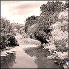
The uncut riparian corridor above Murphy's Crossing provides
a canopy which attracts birds and provides habitat for numerous species.
Watershed crosses jurisdictions
The Pajaro watershed encompasses four counties and includes four cities: Gilroy, Hollister, Watsonville and Morgan Hill in addition to the unincorporated town of Pajaro. All have urban areas located within the flood plain. As many as 20 or more agencies have jurisdiction in managing parts of the river.
What happens upstream has an impact on the downstream communities. Urban policies and zoning laws, both upstream and down have impacts on both the watershed and the wildlife that depend on a healthy, living river to survive. Industrial, commercial and residential construction is still allowed in the flood plain by all the cities and counties. In the four cities, urban growth exceeds the state average. A so-called “peaker power plant” has been proposed to be built on the flood plain in the town of Pajaro.
As more land is developed and paved over, runoff that might have previously soaked into the ground, will be collected by storm sewers and dumped into the river.
| |
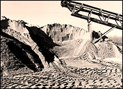 Sand and gravel operations pile the river bed with slag
heaps and destroy spawning, nesting, and feeding habitat.
Sand and gravel operations pile the river bed with slag
heaps and destroy spawning, nesting, and feeding habitat.
|
Many factors influence
the amount of water in the river: Development within the flood plain, destruction
of vegetation in the name of flood control, abrupt and ill-timed water releases
from upstream reservoirs, dumping of treated effluent from sewer plants, industrial
sand and gravel operations and other alterations of the channel. All have impacts
on native wildlife. Vegetation stabilizes the levee system, filters sediments,
controls erosion, provides scenic values, reduces channel maintenance costs, lowers
water temperature and provides habitat.
Steelhead, a federally listed species, require clean water, a gravel bottom, a mature riparian corridor to provide shade for moderating water temperatures and large submerged roots for shelter. But over 95% of riparian vegetation in California has already been destroyed. Each clearing of this vegetation eliminates a structurally complex canopy that supports hundreds of bird species and other types of wildlife.
The multiplicity of agencies presently involved in management of “their” section of the Pajaro River defeats coherent planning. The need for a joint powers agency was recognized long ago by Senator Henry Mello, but his efforts were short-circuited by term limits. Assembly Member Fred Keeley restarted the effort, which has helped to increase communication among some of the agencies involved. However, the move to form a joint powers agency is presently stalled.
Protection of the Pajaro watershed is further complicated by the fact that very few of the hundreds of thousands of acres contributing water to the Pajaro and its tributaries are in the public domain. Instead private lands, which constitute most of the watershed, are used for agriculture, extractive sand and gravel operations, and increasingly, subdivisions, shopping malls and business developments such as the proposed Cisco campus.
Sand and gravel operations pile the river bed with slag heaps
and destroy spawning, nesting, and feeding habitat.
Currently the Corps of Engineers is proceeding with exploration of its proposed alternatives for flood control. They have asked the Fish and Wildlife Service to conduct a biological assessment from which a draft Environmental Impact Statement will be prepared.
Sierra Club position
During June the Ventana Chapter and Santa Cruz County Group of the Club will be developing a formal position statement on the Pajaro watershed in cooperation with the Loma Prieta Chapter in order to be able to comment on the alternatives proposed by the Corps of Engineers and to offer alternatives of our own. Interested members are encouraged to contact Lois Robin, Larry Espinosa or Jo Ann Baumgartner.
Lead activist: Jo Ann Baumgartner
< back to all issues
|
|

|