| |
|
|
Sand Mining on the Monterey Bay
September 2008 MEMORANDUM Executive Summary Along the California coast, 75 to 95 percent of all beach sand is provided by rivers that empty onto the coastal plain while approximately 86 percent of this coastline is under active erosion. Human actions have had a major impact on the ability of rivers to deliver sand, thus affecting the shoreline. These actions include reservoir dam building, flood control systems, an increase in impervious surfaces, and sand mining. In the southern Monterey Bay, sand mining has been the largest human contributing factor to erosion, extracting as much as 180,000 yd3/yr of sand, and still continues today. Such removal not only threatens the aesthetic appeal, recreational use, and structures of the area's coastline, but also the sensitive ecological habitats that exist there. In light of this, it is suggested that the Sierra Club join the Coastal Sediment Management Workgroup's recommendation to close or buyout the existing CEMEX sand mine operation in Marina. Introduction In California, the coastline can be divided into a set of distinct, essentially self-contained littoral cells or beach compartments (Patsch and Griggs 2006). These compartments are geographically limited and consist of a series of sand sources (such as rivers, streams and eroding coastal bluffs) that provide sand to the shoreline; sand sinks (such as coastal dunes and submarine canyons) where sand is lost from the shoreline; and long-shore transport or littoral drift that moves sand along the shoreline (Patsch and Griggs 2006). Sediment within each cell includes the sand on the exposed or dry beach as well as the finer- grained sediment that lies just offshore (Patsch and Griggs 2006). Most beach sand along the coast of California is transported from north to south as a result of the dominant waves approaching the shoreline from the northwest, although alongshore transport to the north occurs in some locations and at certain times of the year in response to waves from the south (Patsch and Griggs 2006). Average annual rates of littoral drift typically range from about 100,000 to 1,000,000 yds3/yr along the California coast (Patsch and Griggs 2006). Like much of the region, southern Monterey Bay beach sand moves on and offshore seasonally in response to changing wave energy, and also moves alongshore, driven by waves that usually approach the beach at some angle (Patsch and Griggs 2006). Depending on the location along the California coast, 75 to 95 percent of all beach sand is or was provided by rivers that empty onto the coastal plains (Griggs and Savoy, 1985). Human actions have had a major impact on the ability of rivers to deliver sand, thus affecting the shoreline. These include reservoir dam building, flood control systems, covering of natural landscape with pavement and structures, and sand mining. Dams reduce the amount of fresh water flows to coastal beaches and wetlands, where reduced flood flows prevent the flushing of sediment from inland sites through estuaries and onto coastal beaches. Flood control systems trap sand that would normally nourish the coastal beaches. These beaches would otherwise be the primary natural buffer acting as protection for sea-cliffs and coastal development from erosion and storm damage. The covering of natural landscape with pavement and structures prevents precipitation and runoff from naturally soaking into the soil. And, in the coastal region, sand mining can be one of the largest contributing factors in anthropocentric caused erosion. Regardless of cause, approximately 86 percent of the coastline of California is under active erosion (Griggs and Savoy, 1985), however, the extent and rate of erosion varies depending on the location and the physical characteristics of the coastline. Under the normal process of erosion and bluff retreat, the beach itself remains relatively stable in size and depth, but progresses inland as the bluff or shoreline erodes forcing the coast to simply migrate landward naturally. Depending on annual to semi-annual weather conditions such as El Niño events, this retreat may vary from a few inches to a few feet a year (Griggs and Savoy, 1985). 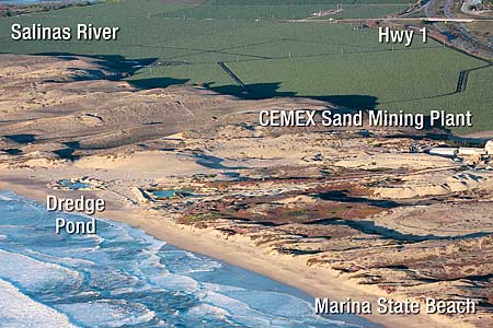 Sand Mining Sand mining is a practice that is becoming an ecological problem as the demand for sand increases in industry and construction. Sand is mined from beaches and inland dunes and dredged from ocean beds and river beds. It is often used in manufacturing as an abrasive and it is a primary component in the production of concrete. Ultimately, as communities grow, construction requires less wood and more concrete, leading to an increasing demand for low-cost sand. The process of sand mining requires that sand and gravel be removed from riverbeds, beaches, dunes or near-shore areas which represent a significant permanent sink for some of California's littoral cells. Overall in northern California, (i.e., from the Oregon border to the Russian River), about 8 million yds3 of sand and gravel are removed each year from the coastal streambeds (Magoon and Lent, 2005). In southern California, the annual total is nearly 41 million yds3, primarily in the greater Los Angeles and San Diego areas (Patsch and Griggs 2007). Beach sand mining was terminated along the coast of California by the late 1980's to early 1990's in all areas except for the town of Marina in the southern Monterey Bay, where mining of the back beach is still occurring (Patsch and Griggs 2007). 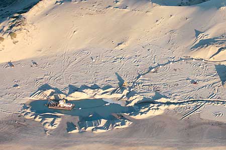 Sand Mining in the Southern Monterey Bay Beach sand mining began in 1906 at the mouth of the Salinas River. By the 1950's, mining operation had expanded to six commercial sites at Marina and Sand City (Habel and Armstrong 1978); (Magoon, 1972). Beach sand mining operated unregulated until 1968 when leases were issued and managed by the State Lands Commission. In 1974, the U.S. Army Corps of Engineers put additional regulations in place. Leases on all but one beach mining operations expired in the late 1980's (Patsch and Griggs 2007). As of 1990, mining of the surf zone was discontinued. However, one mining operation, owned by CEMEX, still exists on the beach at Marina where sand is dredged from the back beach, and therefore, effectively removed from the littoral system. For this reason, the CEMEX plant is exempt from the original decision by the Army Corps of Engineers to cease all shoreline mining operations. Between 1940 and 1984, it is estimated that an average of between 128,000 and 180,000 yd3/yr of sand was mined from the beaches of the southern Monterey Bay, resulting in the permanent loss of this sand (Patsch and Griggs 2007) (Thornton, Sallenger, et al. 2006). Erosion Factors Due to a persistent rise in sea level, changes in sand availability, and previous unsustainable public and private development practices, the southern Monterey Bay coastal dunes south of the Salinas River are eroding, on average, at the fastest rate in California (AMBAG 2008). Erosion compromises the ability of the dunes and beaches to buffer the oceanfront development and infrastructure from storms and flooding; provide vital natural habitat; and, successfully accommodate recreation and tourism (AMBAG 2008). This is in part due to sea level rise but also to the large beach sand mining operations that were common in the area. Dune erosion, which occurs with the recession of the bluff-top edge of the dune, nourishes the beaches throughout the cell. In addition to the sand supplied to the beaches through dune erosion, sand is added to this littoral cell from the Salinas River located near the north end of the cell (Patsch and Griggs 2007). Dune erosion is highly episodic, and occurs when large storm-generated waves coincide with high tides (Dingler and Reiss 2002). This erosion is exacerbated during El Niño winters when storm waves intensify (Patsch and Griggs 2007). Erosion of the dunes occurs more often in the winter months when storms are more powerful and frequent, and when the protective fronting beaches are narrower, thus leaving the dunes exposed and vulnerable to erosion (Patsch and Griggs 2007). Dune erosion occurs when wave swash or run-up undercuts the base of the dunes causing the overlying sand to slump onto the beach (McGee 1987). This sand is washed out with the retreating waves where most of it becomes part of the littoral drift system (Patsch and Griggs 2007). Despite the cessation of sand mining, the beach and dunes are still eroding at a relatively high rate (Thornton, Sallenger, et al. 2006). Long-term erosion rates for the dunes in the southern Monterey Bay were determined to be on the order of 1.6 ft/yr in the south end of the central sub-cell near Monterey, increasing to a maximum of 5 feet/yr around Seaside and subsequently decreasing northwards towards the Salinas River (Thornton, Sallenger, et al. 2006). One of the most notable examples of this took place in Fort Ord where a football field existed on the dune between Stillwell Hall and the ocean in 1944. After the field eroded into the ocean, rock rubble was placed in front of Stillwell Hall in 1978 and again in 1985 to stop erosion, but even after sand mining ceased, extreme recession continued to occur at the flanks of the rubble. Up to 14m of recession occurred during the 1997-98 El Niño winter just to the north of Stillwell Hall and in 2004, the hall was removed to prevent the structure from eventually falling into the sea. Remaining CEMEX Facility in Marina The remaining sand-mining operation in Marina is owned and operated by CEMEX, the world's largest building materials supplier and third largest cement producer and is located at the end of Lapis Road. The site is a hydraulic sand mining operation that employs water to dislodge rock material or move sediment. The sand is mined by a floating dredge creating a large pond just landward of the beach berm. It is then pumped to a dewatering tower, kiln dried, screened and blended at a processing plant on the site (AMBAG 2008). The height of the berm is at a similar elevation to the toe of the adjoining dunes (AMBAG 2008). This mining operation efficiently takes advantage of the cross-shore sorting of sediment where coarse sand is washed over the berm to fill the pond during times of high winter waves and high tide. The pond is refilled with sediment every year as documented by aerial photographs (AMBAG 2008). The total amount of sand sold annually today from the ongoing operation at Marina is 3.0 million tons, or approximately 235,000 yd3/year (AMBAG 2008). It is assumed that at least 85% of the sand mined is from the dredge pond (the other 15% from dune sand), or approximately 200,000 yd3/year (AMBAG 2008). This value is conservative (some dune sand is mixed with the beach sand to create the correct constitution for construction sand) and similar to the estimate obtained by assuming the pond is effectively filled every year and subsequently dredged to the area measured from aerial photographs, which is approximately 20,000 yd2 (AMBAG 2008). The maximum depth of the dredged pond is based on the depth to which the dredge can reach, which is estimated to be 23-33 feet based on the reach of the dredge head (AMBAG 2008). Assuming the pond could be dredged to the maximum depth, and no sand migrates into the pond from the ocean during the dredge period, the potential amount of sand mined ranges from 153,000 to 220,000 yd3/year, which is consistent with the reported amount (AMBAG 2008). Flora and Fauna The beaches and dunes of southern Monterey Bay provide habitat for numerous native animals, including the threatened western snowy plover and numerous rare plants. Sensitive sub-tidal habitat, including rocky reef, kelp forests, and eelgrass beds, are located adjacent to Monterey Harbor (AMBAG 2008). The complete removal of vegetation and destruction of the soil profile also destroys habitat above and below the ground as well as within the aquatic ecosystem, resulting in the reduction in faunal populations. Those populations include: gracilaria, ulva, tube-dwelling anemone, sand-rose anemone, hydromedusa, nudibranch, Cooper's nutmeg, purple olive snail, painted limpet, moon snail, Pacific electric ray, sanddab, sea otter, and gulls. Further, the 400-acre area that comprises the present sand mining operations includes some of the best preserved dune habitats in the state. Wildlife species specifically found here include the federally threatened western snowy plover, the federally endangered Smith's blue butterfly and black legless lizard. Plant species that are protected include several threatened or endangered species including Yadon's wallflower, sand gilia, and Monterey spineflower (LandWatch, Monterey County 2001). As the dune system has been reduced and fragmented, the risk of extinction has increased for some of these species. For this reason, evaluation of potential impacts to these fragmented population remnants needs to be considered in the larger context of cumulative impacts as well as site specific impacts. Conclusion It is suggested that the Coastal Sediment Management Workgroup (CSMW) be included in any future recommendations by the Sierra Club. The workgroup's objective is to provide consensus-driven management and policy recommendations on ways to reduce shoreline erosion through implementation of regional sediment management and beneficial re-use of sediment; reduce the proliferation of protective shoreline structures; sustain recreation and tourism; enhance public safety and access; and, restore coastal sandy habitats. In June, 2008, the CSMW concluded in its Coastal Regional Sediment Management Plan that, "The current mining operation at Marina continues to contribute significantly to erosion in southern Monterey Bay. The current mining rate is similar in magnitude to the total sand mining rate prior to 1986." The Plan recommends that in order to eliminate factors that exacerbate erosion, the sand mining operation at Marina be closed or bought-out. The report goes on to say, "The large extraction of beach sand by this operation permanently removes sediment that would otherwise feed beaches elsewhere along southern Monterey Bay. If this sediment is released and subsequently transported south, it could provide a significant additional buffer to dune erosion from waves. The effect would be more immediate in Marina, but would eventually benefit the shoreline further south as the sediment migrates south." Due to the ecological impacts associated with the sand mining operations, it is suggested that the Sierra Club join the Coastal Sediment Management Workgroup's recommendation to close or buyout the existing CEMEX sand mine operation in Marina. References AMBAG. Coastal Regional Sediment Management Plan for Southern Monterey Bay. Draft Plan, Monterey: Association of Monterey Bay Area Governments, 2008. AMBAG. Coastal Regional Sediment Management Plan For Southern Monterey Bay: Public Fact Sheet. Monterey: The Association of Monterey Bay Area Governments, 2008. Borges, P, C Andrade, and M Freitas. "Dune, Bluff and Beach Erosion due to Exhaustive Sand Mining — the Case of Santa Barbara Beach, São Miguel (Azores, Portugal)." Journal of Coastal Research, 2002: 89-95. California Department of Boating and Waterways. Shoreline Erosion Protection Policy. Sacramento: California Department of Boating and Waterways, 1978. California State Lands Commission. Shoreline Protective Structures. Sacramento: California State Lands Commission, 2001. Dingler, JR, and TE Reiss. "Changes to Monterey Bay Beaches from the End of the 1982-83 El Nino Through the 1997-98 El Nino." Marine Geology, 2002: 249-263. Griggs, Gary. "Littoral Cells and Harbor Dredging Along the California Coast." Environmental Geology and Water Sciences, 1987: 7-20. Griggs, Gary, and Lauret Savoy. Living with the California Coast. Duke University Press, 1985. Griggs, Gary, KB Patsch, and Lauret Savoy. Living with the Changing Coast of California. Berkeley: U.C. Press, 2005. Habel, JS, and GA Armstrong. Assessment and Atlas of Shoreline Erosion Along the California Coast. Sacramento: State of California, Department of Navigation and Ocean Development, 1978. Inman, D, and J Frautschy. "Littoral Processes and the Development of Shorelines." ASCE, 1966: 511-536. King, Philip, and Douglas Symes. The Potential Loss in Gross National Product and Gross State Product from a Failure to Maintain California's Beaches. Sacramento: California Department of Boating and Waterways, 2003. LandWatch, Monterey County. LandWatch: City of Marina Community Reports. April 10, 2001. Magoon, OT. "Coastal Sand Mining in Northern California." ASCE, 1972: 1571-1598. Magoon, OT, and LK Lent. "The Costs of Sand Mining: When Beaches Disappear, Who Benefits, Who Pays?" California Coast and Ocean, 2005: 3-8. McGee, T. "Coastal Erosion along Monterey Bay." Sacramento, 1987. Patsch, K, and G Griggs. Littoral Cells, Sand Budgets, and Beaches: Understanding California's Shoreline. Santa Cruz: Institute of Marina Sciences, University of California, Santa Cruz, 2006. Patsch, Kiki, and Gary Griggs. Development of Sand Budgets for California's Major Littoral Cells. Santa Cruz: Institute of Marina Sciences, University of California, Santa Cruz, 2007. The Ojos Negros Research Group. Sand Mining Facts. February 11, 2004. http://threeissues.sdsu.edu/three_issues_sandminingfacts0.html (accessed July 13, 2008). Thornton, Edward. "Sand Mining Impacts on Shoreline Erosion in Southern Monterey Bay." Proceedings of Coastal Zone. Portland: Navel Postgraduate School, 2007. Thornton, Edward, A Sallenger, Juan Sesto, Laura Egley, Timothy McGee, and Rost Parsons. "Sand Mining Impacts on Long-Term Dune Erosion in Southern Monterey Bay." Marina Geology, 2006: 45-58. Vasquez, Raul. "Top local scientists will discuss coastal erosion at upcoming meeting in Monterey." Monterey Weekly, July 6, 2006: http://www.montereycountyweekly.com/archives/2006/2006-Jul-06/Article.news_1/1/@@index Shoring Up Support accessed July 13, 2008. |
Current CCC Votes Unanimously For Closure of CEMEX Plant July 2017 CCC to Hold CEMEX Plant Hearing at July Meeting June 2017 Marina Is Going Solar! June 2017 Chapter Approves Trust Fund Grant for Coastal Habitat Restoration Project in Marina October 2013 Beach erosion caused by CEMEX sand mining in Marina January 2012 Chapter member appointed to Regional Water Board December 2011 Habitat Trust Fund producing results in Marina December 2009 Marina commits to sustainability August 2008 Getting close to nature is easy in Marina August 2008 Bioretention on Monterey Bay September 2008 Sand Mining on the Monterey Bay September 2008 Freedom of Information Act Request letter regarding CEMEX sand mining plant (132kB pdf) August 2008 Draft - Coastal Regional Sediment Management Plan for Southern Monterey Bay (3.9MB pdf) August 2008 Getting close to nature is easy in Marina August 2008 Club involvement greens up Marina development March 2008 Marina applies to delete section of Coastal Zone designation October 2007 Will Marina's growth be green? October 2007 More money in Marina conservation account October 2007 $230,000 available for dune habitat in Marina June 2007 |
